
Crockmore [An Cnoc Mor]
Good walks are even better shared.
Overview
Crockmore [An Cnoc Mor]
Nestled in the heart of Northern Ireland, Crockmore, or An Cnoc Mor, offers a delightful escape for hikers looking to enjoy both natural beauty and a bit of adventure. Standing proud at 528 meters, it may not be the tallest mountain in the region, but its charm is undeniable.
Geology
Crockmore is primarily composed of sedimentary rocks, particularly sandstone and mudstone, remnants from the Carboniferous period. This makes for fascinating walking, as hikers can witness the layers of history beneath their feet.
Routes
Starting from the C103 road, the most popular route is a 5 km trek that typically takes around 2.5 hours. This moderate trail features a mix of grassy slopes and rocky terrain, offering challenges that keep your heart rate up and your spirit high.
Summit Features
At the summit, you'll find a modest cairn and the reliable trig point, both of which provide perfect spots for those all-important summit selfies. The views are simply breathtaking, rewarding your efforts with expansive vistas.
Terrain Type
The terrain is mostly grassy with occasional rocky outcrops, but beware of the boggy patches that can catch you off guard, especially after rainfall. It’s a bit of a mix—a bit like life really!
Views
From the top, prepare to feast your eyes on stunning sights:
- To the south, the majestic Mourne Mountains rise in all their glory.
- To the east, the rolling hills of County Down stretch as far as the eye can see.
For the best viewing experience, aim for late spring or summer. That way, the heather is in full bloom, making the hillsides even more picturesque.
Hazards
While there are no major hazards, it’s advisable to be careful in muddy conditions. Slippery trails on wet days can turn your hike into an unexpected mudslide—unless that's the kind of adventure you're after!
Nearby Summits
If you’re looking to explore further, consider tackling these nearby peaks:
- Slemish Mountain (495 meters)
- Slieve Gullion (573 meters)
Access
- Nearest Parking: There’s limited parking along the C103 road, but be mindful as it can fill up quickly on weekends.
- Public Transport: Limited options mean a car is preferred for convenience.
- Nearest Town: The charming town of Ballymena, about 14 km to the north, has all you need before or after your hike.
Facilities
Local infrastructure is sparse on the mountain. For cafes or toilets, head back to Ballymena where you can replenish your energy and refresh your spirits.
History
The name An Cnoc Mor translates to 'The Big Hill'—a title that its prominent presence more than justifies. While it may not have the fame of its taller neighbours, Crockmore is cherished among locals and avid hikers alike for its serene landscape and easy accessibility.
In summary, Crockmore lies quietly in the shadow of its more renowned counterparts but rewards anyone willing to tread its paths with views, nature, and the kind of satisfaction that only a hike can offer. So, grab your boots, pack some snacks, and prepare for a delightful day on this big hill. Just remember, if you see a rabbit, it's not a sign of bad luck; it's just your reminder to hop along and enjoy the journey!
Explore routes near Crockmore [An Cnoc Mor]
Public walks starting within 80 km of this hill. Nearby does not mean a route reaches the summit; check its map and access before setting out.
Derry~Londonderry City Walls Circuit
View route
Banagher Glen and Forest: complete higher-return circuit
View route
Route planning notes
These notes describe possible approaches, not verified navigable routes or permission to cross land. Check current paths, local access rules and conditions before setting out.
Crockmore via the C103 Road
A scenic route starting from the C103 road leading up to the summit, with a mix of grassy slopes and rocky terrain.
Make a day of it, together
Find someone to share the walk with, or organise a day out along a route you like.
Hill facts and local notes
Classifications
Elevation
349m
1,145 ft
Prominence
173m
Coordinates
55.0803, -7.8426
C101259
OS Map
02
At the Summit
The summit hosts a modest cairn and offers panoramic views of the surrounding countryside, as well as a trig point that reminds hikers they’re not just wandering aimlessly.
Terrain & Geology
The surrounding areas are characterised by sedimentary rocks, primarily sandstone and mudstone, which were formed during the Carboniferous period.
Views & Scenery
On a clear day, one can see the Mourne Mountains to the south and the rolling hills of County Down stretching eastward.
History & Heritage
Name Origin
The name 'An Cnoc Mor' translates to 'The Big Hill' in Irish, a fitting description for this prominent feature in the landscape.
Historical Significance
Although not as famous as other peaks, Crockmore holds significance for local hikers and is appreciated for its untouched beauty.
Getting There & Facilities
Check current local access restrictions, parking rules and transport timetables before travelling. These notes do not confirm public access to the summit.
Parking
There is a small pulloff area on the C103 road with space for several cars, though it can fill up quickly on weekends.
Public Transport
Public transportation options are limited; it’s advisable to use a car or arrange a taxi to the starting point.
Nearby Facilities
There are few facilities on the mountain; however, points of interest and cafes can be found in Ballymena for pre-hike fuel and post-hike relief.
Safety Information
Known Hazards
- Care should be taken on wet days as the trails can become slippery. In spring, the area may be muddy and boggy, so waterproof boots are recommended.
General Safety Tips
- Check weather conditions before setting out
- Carry appropriate clothing and equipment
- Let someone know your planned route
- Take a map, compass, and GPS device
- Carry emergency supplies: food, water, first aid kit, torch
Hills
Some common questions about the hills answered
Are there group walks up Crockmore [An Cnoc Mor]?
Many walkers use Walkmates to join or organise walks with others. You can check for group walks around Crockmore [An Cnoc Mor] through the maps
Are there other walkers around Crockmore [An Cnoc Mor]?
Activity varies by location and time, but Walkmates lets you see whether others have shared walks or shown interest in this area. Find other people through the walking friends search walking friends for Crockmore [An Cnoc Mor] search or of course create your own walk for Crockmore [An Cnoc Mor]
Can I organise a walk to Crockmore [An Cnoc Mor]?
Yes. If there aren’t any walks listed already, you can create a walk and make it available for others to join.
If you're signed up to Walkmates, you can create a walk to Crockmore [An Cnoc Mor].
How do I find a walk up this hill?
There are often multiple ways to walk this hill, depending on experience and route preference. Walkmates helps you explore walks and routes that others have shared.
Can I suggest a new route up Crockmore [An Cnoc Mor]?
Yes. You can suggest or create routes to share with others. Walkmates focuses on the social side of walking, so routes are used to help people organise walks and explore areas together, rather than as detailed navigation tools or route libraries.
Other uses really appreciate knowledgeable walkers sharing their routes. Share your favourite route to Crockmore [An Cnoc Mor] here
The is an error or something incorrect about this hill. How do I let you know?
We always strive to keep the information on Walkmates as accurate as possible. If you find an error, please let us know through the contact form and we'll aim to correct it as quickly as possible
Community Discussion
Comments
Location
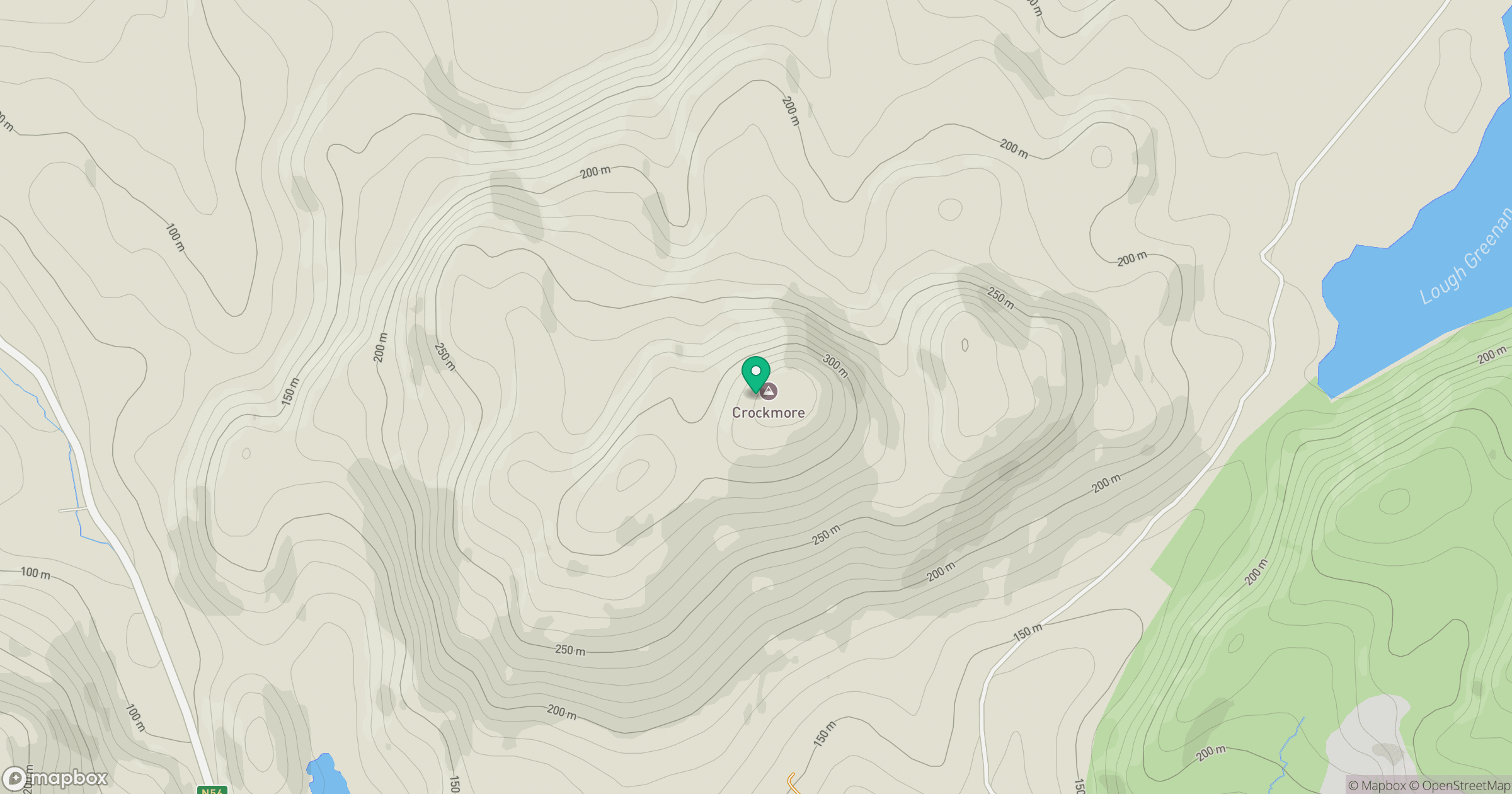
Grid reference: C101259
View on OpenStreetMapOpens a map in a new tab, centred on the hill.
Hills within 30 km
Straight-line distance, not a walking route or confirmation of access.
No comments yet. Be the first.